The Erosion Lab
In collaboration with NYU Applied Mathematics Lab Researcher Samuel Boury and his paper, Sculpting the Sphinx
The Erosion Lab is a tactile-digital installation that transforms research on landform erosion into an interactive, allowing users to shape landscapes by controlling wind velocity, duration, and direction.
Team
Samantha Cui
Georgia Chen
Cindy Hu
Chumou Zhang
Responsibility
Concept Development, Presentation Design, System Design, Digital Interface Development, Fabrication.
Timeline
February 2024 - May 2024 (3.5 Months)
Overview
Made with
Hardware - 3D printed conveyor belts, PC Screen, Arduino controls, linear actuators.
Software - Blender, p5.js, Adobe Illustrator, Figma, Arduino IDE, Fusion 360.
How can interactive technology be used to transform complex research into digestible experiences?
Interactions Breakdown
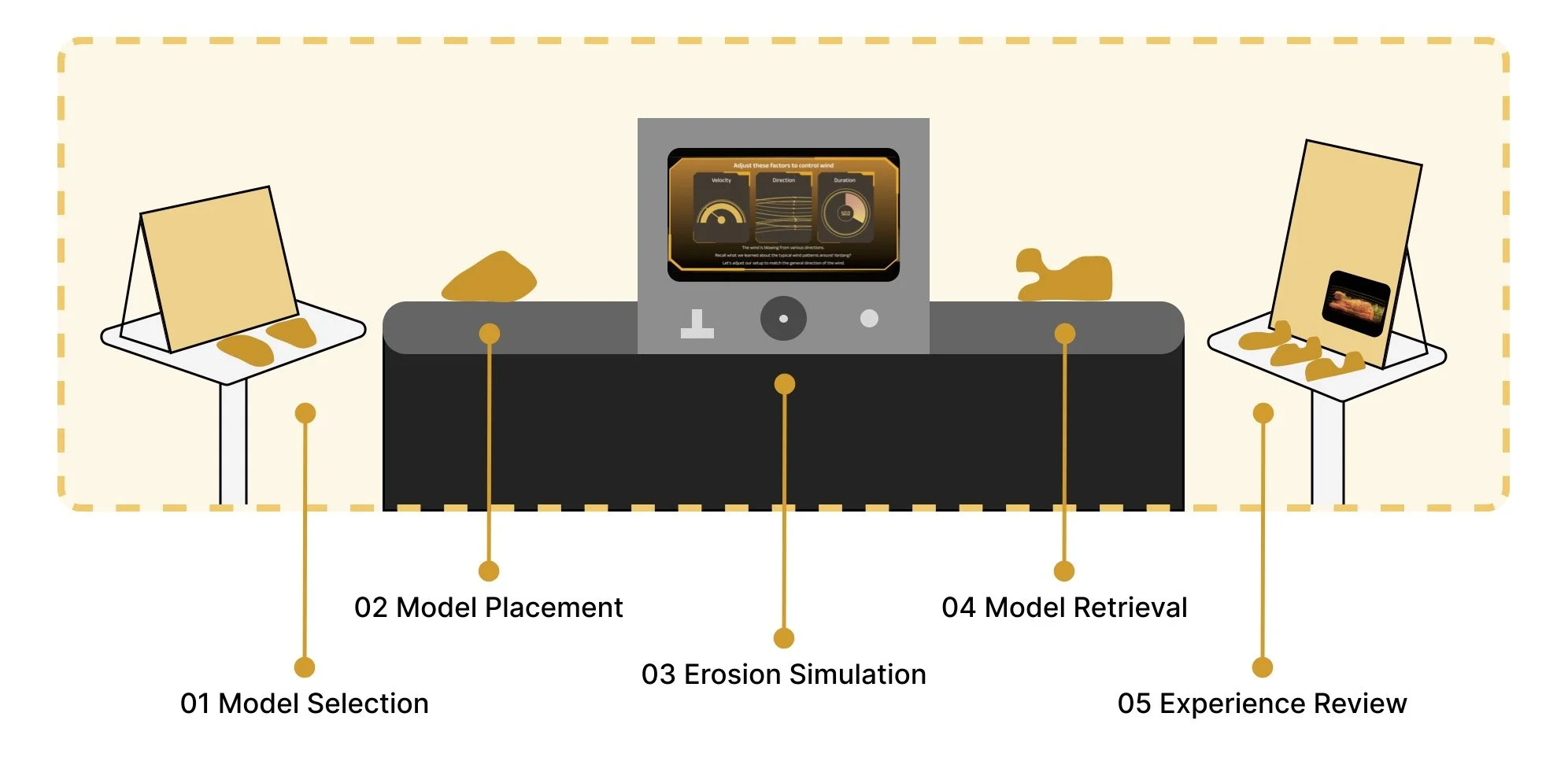
01 Model Selection
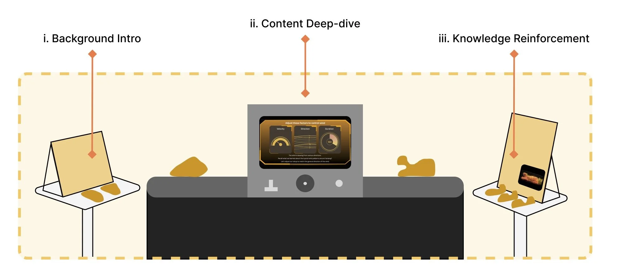
Upon entering the installation, visitors will first encounter a panel introducing the basic concepts of landform erosion. They will then choose between two models, each representing a different land density, with hints about their potential outcomes. However, the full impact will only be revealed at the end, encouraging visitors to restart the process with the other model for comparison.
02 Model Placement
After selecting a model, visitors will place it onto the conveyor belt, where sensors beneath detect its presence. Once recognized, the belt automatically starts, initiating the erosion simulation and guiding visitors’ attention to the central black box as the model moves forward.
03 Erosion Simulation Control
Following instructions given on the screen, visitors adjust three parameters to shape the erosion outcome and lock in their settings before proceeding to the erosion simulation.
Wind Velocity
Based on the research, the wind velocity is set at a fixed value. Visitors push a lever to activate the predetermined wind speed.
Wind Direction
To acquire wind direction, visitors rotate the center wheel to align airflow from multiple directions into a single horizontal direction.
Wind Duration
As wind duration significantly affects erosion outcomes, visitors rotate the center wheel to set their desired duration. There is no correct answer for this choice.
Submit Results
After setting their desired duration, visitors press the yellow button to submit and lock in their control parameters, initiating the erosion simulation.
Watch Erosion Progress
Visitors watch the erosion process unfold, while an information panel at the top displaying their control inputs.
04 Model Retrieval
After the erosion process is complete, the eroded model will emerge from the other end of the black box, following the conveyor belt. The belt will stop once it reaches the final retrieval position. Visitors can then pick up their eroded model and bring it to the experience review table to closely observe the results.
05 Experience Review
After picking up their model, visitors bring it to the final examination station, where they can compare it with models of other possible erosion outcomes. They can also fill out a lab report to reflect on their experience. Additionally, they can explore information panels for more detailed insights into landform erosion.
Mapping Out the Experience - Learning Touchpoints
This installation highlights three key factors—wind velocity, duration, and direction—allowing users to embody the wind itself. Through hands-on interactions, participants actively shape and explore the processes of landform erosion, experiencing firsthand how these elements sculpt the landscape.
Using technology to create a sense of magic, the installation seamlessly integrates physical 3D models with interactive digital screens, blurring the lines between the physical and digital realms.
Mapping Out the Experience - Key Interactions
back to Interactive Media
